Paekākāriki coastal hazards
Paekākāriki coastal environment
Paekākāriki is at the southern end of a coastal plain which narrows to less than 200m wide at the base of the coastal escarpment and Paekākāriki Hill. Coastal processes in Paekākāriki are influenced by the shape of the coast at Paraparaumu, which extends west of the rest of the shoreline in a large delta shape. This acts as a natural barrier to longshore sediment transport, reducing the sediment supply to the Paekākāriki shoreline. As a result, the beach has experienced periodic large-scale erosion in significant storms.
People have responded by building a near continuous line of ad hoc public and private coastal protection structures (seawalls) since at least the 1950s. The structures vary in length, type, and age – mostly rock (as shown in photos A and C) and timber seawalls, with a few railway iron and tyre structures. South of The Parade, there is only a small buffer between properties and the shoreline.
Present-day erosion and flood hazards
The present-day erosion hazard is what could occur in an extremely large storm (which has a 1% chance of occurring each year in the immediate/ near future), and if the existing protection structures failed, as shown in photo (B).
Along the Paekākāriki coast, short term erosion is ‘most likely’ to be 7 to 20m of erosion. Due to the high land elevations in Paekākāriki, the present-day flood hazard in the same size event is very minimal and localised to the Wainui Stream and Waikakariki Stream mouths.
Key findings
- Assuming that existing seawalls are not replaced in the future, or no alternative protection measures are implemented, the Paekākāriki shoreline is projected to be susceptible to coastal erosion over the next 30–100 years.
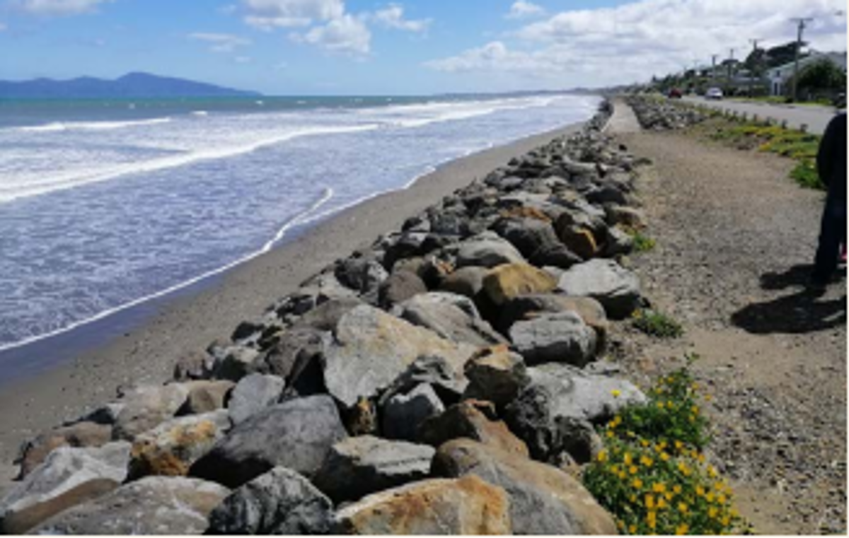 A. Rock revetment structure along The Parade.
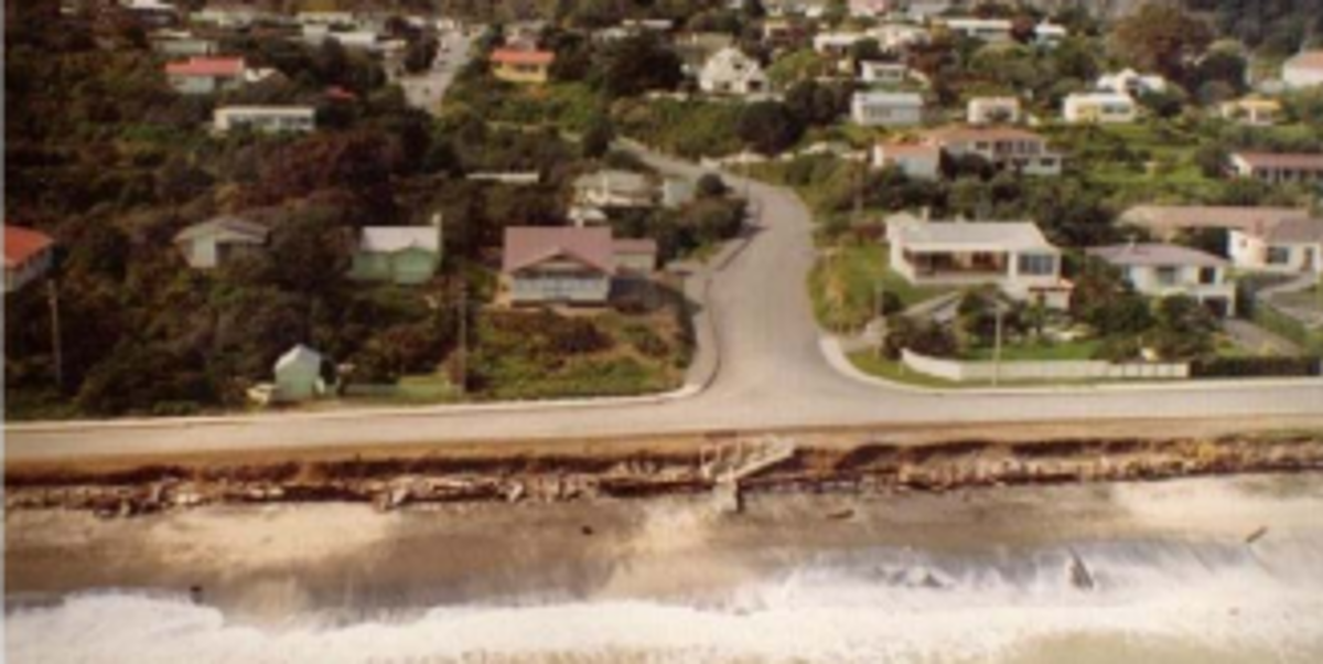 B. Structure failure and coastal erosion following September 1976 storm.
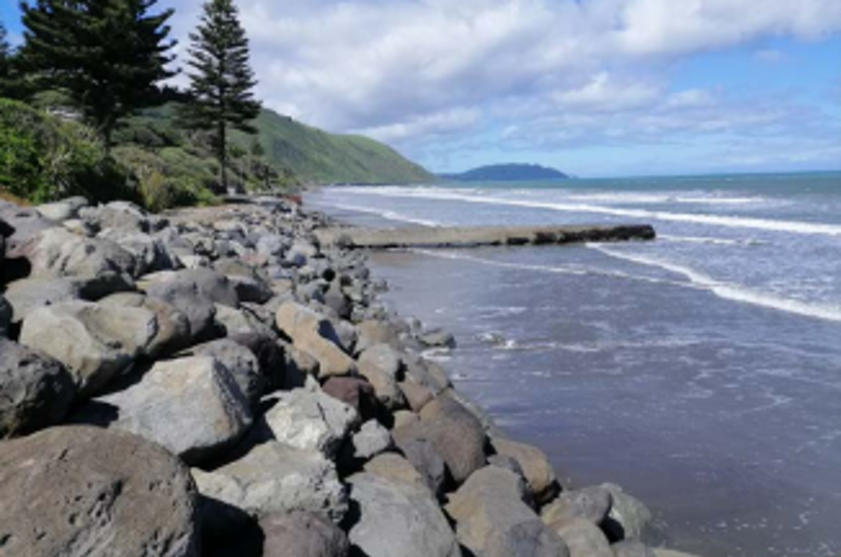 C. Paekākāriki seawall at Beach Road.
- In general, existing seawalls currently provide good protection from coastal erosion, but the beach in front of them could lower 0.8 to 1.4m over the next 30 years as a result of relative sea-level rise (RSLR), which could cause them to fail.
- Paekākāriki is the second most vulnerable area in the district based on the number of private land parcels potentially affected by coastal erosion.
- Paekākāriki is less susceptible to coastal flooding due to the higher land elevation of this section of coast. Flooding is localised to the Wainui Stream and Waikakariki Stream mouth areas.
Future coastal erosion hazard
Future projections of shoreline position take into account the presence of current protection structures up to their estimated remaining life (10–50 years). After this it is assumed that the structures are not replaced, alternative protection measures are not implemented, and the beach reverts to a natural system. The following erosion distances are averages from the upper bound of the ’most likely’ erosion position.
Northern Paekākāriki
Paekākāriki seawall assumed to have at least a 30 year lifetime.
Projected to erode:
- 8m by 2050
- 18 to 26m by 2070
- 52 to 80m by 2130
Southern Paekākāriki
Seawall lifetimes vary from 10–30 years along this section.
Projected to erode:
- 22m by 2050
- 33 to 38m by 2070
- 67 to 89m by 2130
Future coastal flood hazard
Pathways to coastal flooding in Paekākāriki are along the Wainui and Waikakariki Streams. The stormwater drainage network in Paekākāriki is generally raised well above the highest extreme sea level considered in this assessment.
0.35m and 0.45 m RSLR (~2070)
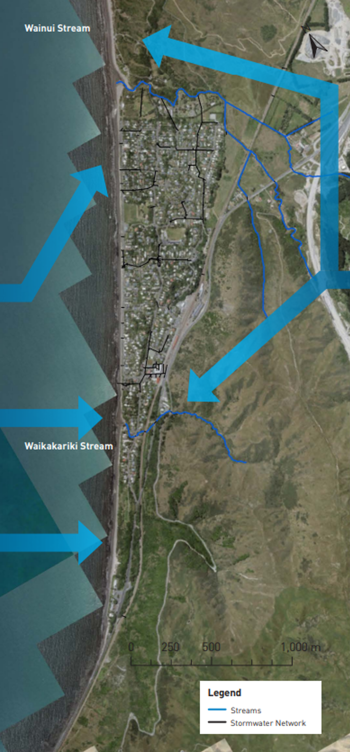
Future flood hazard under lower RSLR scenarios is around the mouths of the Wainui and Waikakariki Streams.
0.85m and 1.25m RSLR (~2130)
Flooding is still mostly localised around the two stream mouths. The mapping shows some localised depressions within the Paekākāriki settlement, which could be susceptible to flooding from stormwater outfalls, but are generally protected by higher surrounding ground levels.
There is a small area around both stream mouths where there could be additional flooding caused by wave run-up
Asset exposure
Over the next 30 years, up to 48 private land parcels could be affected by erosion if existing coastal protection fails; 122–149 over the next 50 years; and 166–225 over the next 100 years. The Parade is projected to be affected by erosion within 30 years if existing coastal protection fails, and parts of Ames Street could be affected in 100 years. State Highway 59 is projected to become affected following the assumed failure of the protection structure after 50 years. 15 coastal stormwater outlets in Paekākāriki are vulnerable to the coastal erosion hazard within the next 30 years.
Vulnerability to coastal flooding in Paekākāriki is significantly less than vulnerability to coastal erosion, with no critical council or community infrastructure mapped to be affected. 32 private land parcels are considered affected by flooding in an extreme storm at the present day, and this increases to 53 land parcels under the 1.25m RSLR scenario in 100 years. It should be noted that the count for land parcels includes those along the shoreline where the seaward boundary currently extends into the beach.
How these hazards have been assessed for Paekākāriki
Coastal science experts from Jacobs assessed the susceptibility of coastal erosion and flooding hazards, and the exposure or vulnerability of land parcels and infrastructure (eg, roads, bridges, three water assets) to these hazards across the entire Kāpiti District.
Government guidance recommends that for detailed hazard and risk assessment in both coastal and non-coastal areas, councils should assess the SSP2-4.5 ‘middle of the road’ climate change scenario, and higher SSP5-8.5 ‘fossil fuel intensive’ climate change scenario.
Coastal erosion
The components used to calculate a potential coastal erosion distance along the Paekākāriki coastline include:
- the natural long-term trend of the shoreline movement (ie, eroding, growing, or stable)
- the amount of erosion which could occur as a direct result of the rise in sea levels compared to land level (termed the Relative Sea Level Rise (RSLR)) over time frames of 30, 50, and 100 years
- short-term storm erosion from an extremely large storm which has approximately a 1% chance of occurring in each year, based on observations from the September 1976 storm, and erosion from dunes restabilising to their natural stable slope following a large storm.
Jacobs used a ‘probabilistic approach’ to tie likelihoods to the erosion distances calculated for each scenario of RSLR. The ‘most likely’ range of shoreline positions has a 33–66% chance of occurring. The ‘unlikely’ shoreline position is where there is a 10% chance that the erosion would reach or be greater than this position.
Coastal flooding
To assess the coastal flood hazard for Paekākāriki Jacobs mapped the area which is susceptible to flooding by a large storm tide which has a 1% chance of occurring in any year. The maps show the flooding that could occur at the present time and in the future, for RSLR scenarios of +0.2m; +0.35m; +0.45m; +0.85m; and +1.25m. Jacobs used a simple ‘bathtub’ approach, where all land below the storm tide water level is mapped as susceptible to flooding, regardless of connection to the sea. The maps also show areas which could be affected by additional flooding due to wave run-up overtopping the dunes.
- Paekākāriki Coastal Hazards factsheet [PDF 875 KB]