Raumati coastal hazards
Raumati coastal environment
Raumati coastal processes are influenced by the shape of the coast at Paraparaumu which extends west of the rest of the shoreline in a large delta shape. This acts as a natural barrier to longshore sediment transport, reducing the sediment supply to the Raumati shoreline. As result, the beach has experienced periodic large-scale erosion in significant storms. People have responded by building a near continuous line of ad hoc public and private coastal protection structures (seawalls) since at least 1955.
Many of these structures failed in subsequent storms (eg, 1976) as shown in photo A, and have since been rebuilt. These structures vary in length, type, and age but are mostly private rock revetment or Council timber seawalls (B). Ground levels behind Raumati Beach are generally high, and above future extreme relative sea-level rise (RSLR) water levels, except for some low-lying areas around stream mouths such as Wharemauku Stream (C).
Present-day erosion and flood hazards
The present-day erosion hazard is what could occur in an extremely large storm (which has a 1% chance of occurring each year in the immediate/ near future), and if the existing protection structures failed, as shown in photo A. Along the Raumati shoreline, this would ‘most likely’ result in 16 to 24 m of erosion.
Mapping shows the Raumati shoreline is not susceptible to flooding from the same sized event, but some locations are susceptible to local surface flooding from wave run-up.
Key findings
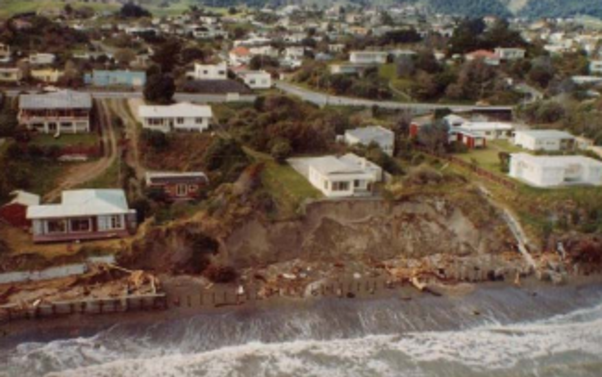 A. Coastal erosion behind failed structures on Rosetta Road following a significant storm in 1976.
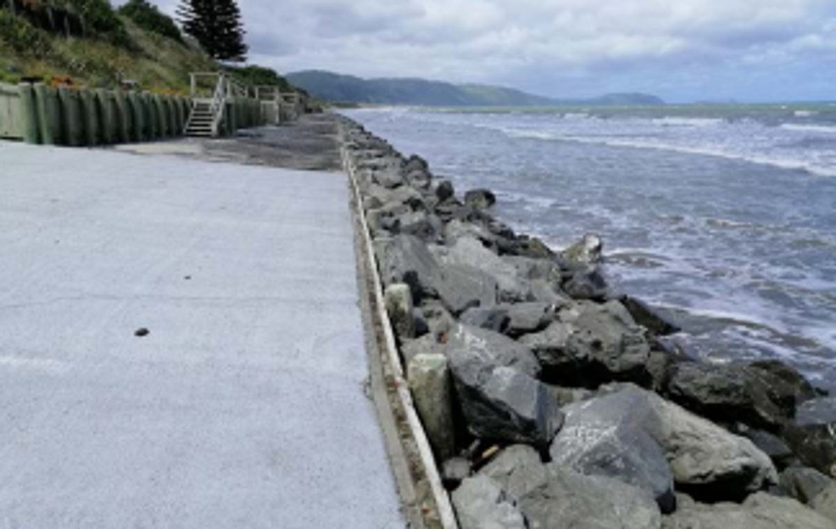 B. Structures along Old Coach Road.
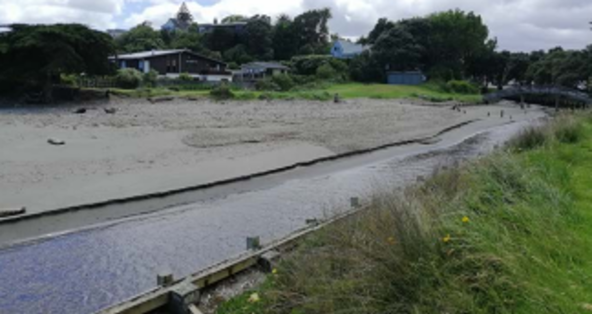 C. Wharemauku Stream.
- Assuming that existing seawalls are not replaced in the future or no alternative protection measures are implemented, the Raumati shoreline is projected to be susceptible to coastal erosion over the next 30, 50 and 100 years.
- Based on the number of private properties potentially affected, Raumati is considered to be the most vulnerable area to coastal erosion along the Kāpiti Coast.
- Due to the higher land elevation, Raumati is less susceptible to coastal flooding except for around the Wharemauku Stream mouth under all RSLR projections, and for lower lying areas around the stormwater network under the higher RSLR scenario (1.25m RSLR).
Future coastal erosion hazard
Future projections take into account the presence of current protection structures up to their estimated remaining life (10–30 years). After this it is assumed that the structures are not replaced, alternative protection measures are not implemented, and the beach reverts to a natural system.
Under these assumptions the Raumati shoreline is projected to erode across all timeframes under all RSLR scenarios. The following erosion distances are averages from the upper bound of the ‘most likely’ erosion position.
Raumati Beach
Projected to erode:
- 31m by 2050
- 41 to 52m by 2070
- 80 to 124m by 2130
Raumati South
Projected to erode:
- 41m by 2050
- 61 to 74m by 2070
- 128 to 179m by 2130.
Future coastal flood hazard
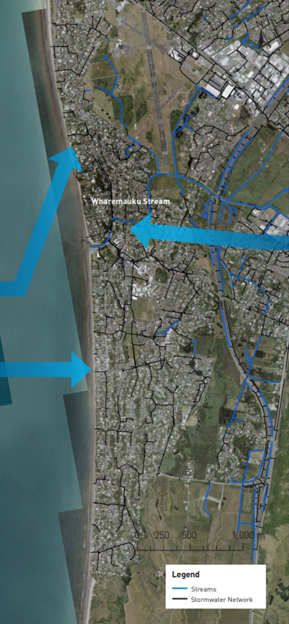
Along the Raumati shoreline, flooding could occur along the Wharemauku Stream and from the stormwater network which drains into local streams and the sea. Stormwater outfalls to the sea also provide potential flooding pathways to some lower lying areas in the dune ridge along the coastline.
0.35m and 0.45m RSLR (~2070)
The area around the mouth of the Wharemauku Stream becomes susceptible to inundation in these two scenarios. The remainder of the Raumati shoreline remains generally unaffected except for smaller stormwater catchments which drain directly to the sea or to the Wharemauku Stream.
0.85m to 1.25 m RSLR (~2130)
Along the Wharemauku Stream the mapping shows an increased area susceptible to both direct inundation from the stream and through the stormwater network – Matatua Road for example – as far upstream as the stormwater ponds on either side of the Kāpiti Expressway. Elsewhere along the coastline the area susceptible to flooding through stormwater outfalls to the sea increases.
Asset exposure
For council infrastructure, a water supply bore and 26 coastal stormwater outlets located along the Raumati shoreline are vulnerable to the coastal erosion hazard within the next 30 years. Some critical roads within the Raumati area also intersect with future shoreline projections under all RSLR scenarios: 1km by 2050, 1.3 to 1.8km by 2070, and 4.6 to 5.5km by 2130. A large number of private land parcels intersect with the projected future shoreline position within each timeframe: up to 280 in the next 30 years depending on the maintenance and upgrades to existing infrastructure, 320-345 within 50 years; and 590-822 within 100 years.
For flooding, key evacuation routes such as Raumati Road are not vulnerable to inundation in extremely large storms, even under the highest 1.25m RSLR scenario in 2130.
How these hazards have been assessed for Raumati
Coastal science experts from Jacobs assessed the susceptibility of coastal erosion and flooding hazards, and the exposure or vulnerability of land parcels and infrastructure (eg, roads, bridges, three water assets) to these hazards across the entire Kāpiti District.
Government guidance recommends that for detailed risk assessment, councils should assess the SSP2-4.5 ‘middle of the road’ climate change scenario, and higher SSP5-8.5 ‘fossil fuel intensive’ scenario. The assessment follows Ministry for the Environment’s ‘Coastal Hazards and Climate Change Guidance for Local Government (2017)’. It advises councils to use the high [RCP8.5H+] scenario to stress-test dynamic adaptive pathways, policies and new greenfield and major infrastructure developments.
Coastal erosion
The components used to calculate a potential coastal erosion distance along the Raumati coastline include:
- the natural long-term trend of the shoreline movement (i.e. eroding, growing, or stable)
- the amount of erosion which could occur as a direct result of the rise in sea levels compared to land level (termed the Relative Sea Level Rise (RSLR)) over time frames of 30, 50, and 100 years
- short-term storm erosion from an extremely large storm which has approximately a 1% chance of occurring in each year, based on observations from the September 1976 storm, and erosion from dunes restabilising to their natural stable slope following a large storm.
Jacobs used a ‘probabilistic approach’ to tie likelihoods to the erosion distances calculated for each scenario of RSLR. The ‘most likely’ range of shoreline positions has a 33–66% chance of occurring. The ‘unlikely’ shoreline position is where there is a 10% chance that the erosion would reach or be greater than this position.
Coastal flooding
To assess the coastal flood hazard for Raumati, Jacobs mapped the area which is susceptible to flooding by a large storm tide which has a 1% chance of occurring in any year. The maps show the flooding that could occur at the present time and in the future, for RSLR scenarios of +0.2m; +0.35m; +0.45m; +0.85m; and +1.25m. Jacobs used a simple ‘bathtub’ approach, where all land below the storm tide water level is mapped as susceptible to flooding, regardless of connection to the sea. The maps also show areas which could be affected by additional flooding due to wave run-up overtopping the dunes.
- Raumati Coastal Hazards factsheet [PDF 703 KB]