Kāpiti Coast District Council Kāpiti Coast District Council
Search
  • Home
  • Rohe | District
  • Kaunihera | Council
  • Ratonga | Services
  • Ngā Kaupapa | What's On
  • Whakapā mai | Contact
  • Rohe | District
    • Aquatics
    • Civil Defence | Emergency Management
    • Libraries
    • Open spaces
    • Our environment
    • Our vision and direction
    • Visiting Kāpiti
    • Beaches
    • Doing business in Kāpiti
    • Maps
    • Our community
    • Our Kāpiti
    • Tangata Whenua
    • Aquatics
    • Beaches
    • Civil Defence | Emergency Management
    • Doing business in Kāpiti
    • Libraries
    • Maps
    • Open spaces
    • Our community
    • Our environment
    • Our Kāpiti
    • Our vision and direction
    • Tangata Whenua
    • Visiting Kāpiti
  • Kaunihera | Council
    • The role of Council
    • Our elected members
    • Delivering for Kāpiti
    • Wellington Region reorganisation
    • Projects
    • Our awards for environmental care
    • Partners
    • Official Information Requests
    • Executive management
    • Meetings
    • Documents
    • Planning
    • Job vacancies
    • Toitū CarbonReduce certification
    • Local elections
    • The role of Council
    • Executive management
    • Our elected members
    • Meetings
    • Delivering for Kāpiti
    • Documents
    • Wellington Region reorganisation
    • Planning
    • Projects
    • Job vacancies
    • Our awards for environmental care
    • Toitū CarbonReduce certification
    • Partners
    • Local elections
    • Official Information Requests
  • Ratonga | Services
    • A–Z council services and facilities
    • A–Z council services and facilities
  • Ngā Kaupapa | What's on
    • News
    • Have your say
    • Things to do in Kāpiti
    • Follow us
    • Everything Kāpiti e-newsletter
    • Calendar of meetings and forums
    • Kāpiti Schools Sports Programme
    • News
    • Everything Kāpiti e-newsletter
    • Have your say
    • Calendar of meetings and forums
    • Things to do in Kāpiti
    • Kāpiti Schools Sports Programme
    • Follow us
  • Whakapā mai | Contact
    • Contact us
    • Follow us
    • About this website
    • Official Information Requests
    • Council facilities opening hours
    • Antenno
    • Social Media terms of use
    • Online service request / Complaints
    • Contact us
    • Council facilities opening hours
    • Follow us
    • Antenno
    • About this website
    • Social Media terms of use
    • Official Information Requests
    • Online service request / Complaints
Search
Close
Hit enter to search or ESC to close
HomeRatonga | ServicesA–Z council services and facilitiesWatersWater supplyWater projectsWater supply projectRiver Recharge SchemeRiver recharge and private bores
Ratonga | Services
  • A–Z council services and facilitieskeyboard_arrow_up
    • Abandoned vehicles
    • Airport noise complaints
    • Alcohol-free zones
    • Building
    • Business licences and permits
    • Cemeteries
    • Citizenship ceremonies
    • Community noticeboards
    • Community venues for hire
    • Council reserve leases
    • Dog and animal management
    • Easements
    • Events
    • Fees and charges
    • Fires
    • Fireworks
    • Grants and funding
    • Housing for older persons
    • Litter and illegal rubbish dumping
    • Noise control
    • Official Information Requests
    • Parks and recreation
    • Payments
    • Property information
    • Public toilets
    • Rates
    • Regulatory performance
    • Resource consents
    • Roads
    • Rubbish and recycling
    • Streetlighting
    • Waters
      • Water supply
        • Restrictions and boil water notices
        • Your supply
        • Where it comes from
        • Treatment
        • Sources and consumption
        • Metering
        • Leaks
        • Water conservation
        • Water education
        • Water projects
          • Waikanae treatment plant upgrade
          • Water supply project
            • River Recharge Scheme
              • River Recharge Resource Consent
              • Questions and answers
              • Water Supply | Annual Reports
              • Award Winning Project
              • River recharge and private bores
              • The future Maungakotukutuku Dam
            • Te Ati Awa Water Working Group
            • Technical Advisory Group
            • Project Maps
            • Project Newsletters
            • Project Reports
            • Project Timeline
            • Water Supply Project FAQs
          • Water meter project
          • Charging Regime Advisory Group
      • Stormwater
      • Wastewater
      • Recreational water quality
      • Three Waters Reform

River recharge and private bores

Use this page to monitor how the river recharge scheme may impact the groundwater levels in your private bore. Follow the easy steps to have up-to-the-minute information on current groundwater levels.

Testing different scenarios | Monitoring groundwater levels and quality | Track groundwater levels in your own bore | What can you do if you have no water?

The river recharge scheme will ensure a high-quality and reliable water supply for Waikanae, Raumati and Paraparaumu for the next 50 years, as demand increases with a growing population.

Completed in May 2015, the scheme will add groundwater to the Waikanae River below the water treatment plant to maintain minimum water flow during dry times. This will ensure bore water does not enter supply. For more information, see kapiticoast.govt.nz/river-recharge-scheme.

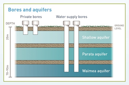
Council will use eight bores to draw water from the 70–90m deep Waimea aquifer for the scheme when/if needed. When we use these bores, the water level in the aquifer decreases.

While private bores don't tap into the deepest Waimea aquifer, water levels in the layers above it could go down when the scheme is operating.


Testing different scenarios

Extensive testing and computer simulation were carried out as part of our consent application to use groundwater for the scheme. A range of population projections and time periods were tested.

Extreme conditions

The worst-case simulation included extracting groundwater for a maximum projected population in Kāpiti in 2060, combined with a 50-year drought. Under this simulation, shallow bores (less than 20m deep) directly adjacent to production wells may experience a temporary decrease in water levels by up to 0.5m, while deeper bores may have a decrease of up to 10m.

Predictive analysis showed no decline in water quality in the Waikanae borefield. Remember, this is a worst-case scenario.
 

Monitoring groundwater levels and quality

As part of our consent, we have an extensive network of monitoring wells in the district to provide on-going information about groundwater levels and quality. Sentinel wells along the coast detect any sea water (saline) intrusion into the aquifers, which could degrade groundwater quality.

If groundwater levels get too low or increased salinity is detected in the groundwater, alarms are triggered alerting staff to respond.

How you can track levels in your own bore

You can check the level of water in aquifers by going to the Waikanae Borefield Level Monitoring website (you will need Chrome, Firefox, Safari or Internet Explorer 9+ to see this information).

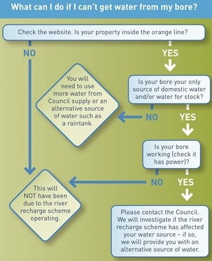
Once on the website, check to see if your property is inside the orange line – bores in this area may experience a noticeable reduction in water levels when the river recharge scheme is operating.

1. Enter the address of your property in the search box at top left of the screen:

map of Waikanae showing water bore locations

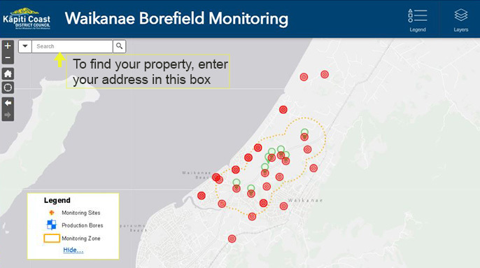
 A blue line will appear showing where your property is located:

Waikanae map zoomed in to show selected property marked with blue line
2. Look for closest monitoring site to your property, marked red:

arrow pointing to closest bore monitoring site to selected property


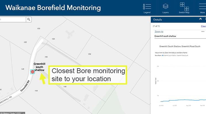
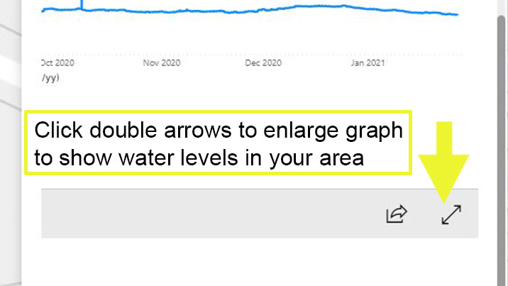
3. Click on the double arrows to enlarge the graph showing water levels at that location:

click the arrows to enlarge graph

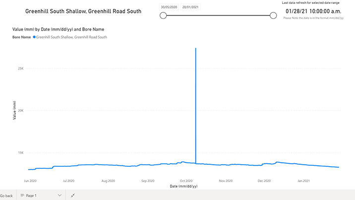
The graph below gives you a closer look at the water level information available. It shows water levels at the Greenhill Road South site in metres above sea level over a seven-day period. While the fluctuation may look large, the change over the period in this case is only around 0.05m or 5cm.

enlarged graph shows water bore usage in selected area

What can you do if you have no water?


Hot topics

  • Grants, funding and awards
  • Maps
  • Public forum at Council
  • Recycling and rubbish
  • Sources and consumption rates
  • Recreational water quality

Quick links

  • Alcohol licences
  • Civil defence
  • Sports ground status
  • Tracking our regulatory performance
  • District Plan
  • Responses to Official Information Requests

Services & information

  • A–Z of services and facilities
  • Job vacancies
  • Information for businesses
  • Property information
  • Maps
  • Kāpiti Coast destination website

Get in touch  facebook  Instagram  Youtube

shielded

Kāpiti Coast District Council
175 Rimu Road
Private Bag 60601
Paraparaumu 5254

Phone: 04 296 4700
Toll free: 0800 486 486
Fax: 04 296 4830
[email protected]

page rip
© Copyright 2022 Kāpiti Coast District Council
SitemapAbout this websiteAccessibilityLegal Notices
NZ Government logo